![]()
![]()
![]()
![]()
![]()
![]()
![]()
![]()
![]()
![]()
![]()
![]()
![]()
![]()
![]()
![]()
![]()
![]()
![]()
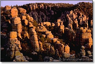
 Chiricahua
National Monument, Arizona
Chiricahua
National Monument, Arizona
Chiricahua Mountains are an extraordinary world of precariously balanced rock monoliths, massive stone columns, stone bridges, and deep canyons. The Mountains are known as the "Land of the Standing-Up Rocks" among the Chiricahua Apaches, who considered the area to be their ancestral homeland. From these mountains, Apaches, led by Cochise and Geronimo, waged a futile battle against the tide of white settlers.
The resistance ended in 1886 when Geronimo's band surrendered and was removed to a distant reservation.
White pioneers settled in the area and started ranching. In 1920s the Erickson family, one of the first non-native families to come, turned their homestead into a guest ranch. They build trails and took visitors on horseback trips to explore the wilderness and delicate cliff formations. Chiricahua Mountains gained increasing attention, and in 1924 the Chiricahua National Monument was established to protect the area's natural wonders.
Geologist believe that the strange formations originated about 27 million years ago, when a volcanic eruption from a nearby Turkey Creek caledra deposited almost a 2,000-foot thick layer of ash. The volcanic ash cooled and fused into a dark volcanic rock known as rhyolite. Extensive water- and wind-born erosion carved the underlying rock into an odd collection of rock formations.
The Chiricahua Mountains are an oasis of life, different from the surrounding Sonoran and Chihuahuan Deserts. These ranges are known as "sky islands" as they are isolated pockets of lush vegetation in the sea of heat and dryness below. Cool and moist forests of the mountain range provide home to a great variety of plant and animal species of the American Southwest, as well as a number of Mexican species. Mexico is 80 km (50 miles) to the south, yet Chiricahua hosts a special mix of species more likely to be found in the Mexican Sierra Madres than in the surrounding highlands. A profusion of plant and animal life, particularly rare birds, attracts thousands of nature aficionados and photographers from far-away places. More than 30 km (20 mi) of hiking trails provide good access to the geological formations.
A good starting place to experience the spirit of this sacred place is to hike the 5.3 km (3.3 mi) Echo Canyon Loop. A variety of geological formations and breathtaking views will make you and your camera work hard. Visit in the late afternoon when cooler air temperatures make hiking easier, and the low angle of sunlight adds three-dimensional aspects to the landscape. You will be hiking at an elevation of over 2000 m (6700 ft) above sea level so do not be surprised if you experience shortness of breath. Use a high SPF sunblock lotion, and take plenty of drinking water with you.
To get to the Echo Canyon, take the Bonita Canyon Drive from the Chiricahua NM visitor centre almost all the way to the Massai Point overlook. Remember to pick up an informative hiking map at the visitor centre. After approximately 5 km (8 mi), watch for the Echo Canyon parking lot on your right. The trail is moderate in difficulty, with 700 ft. elevation gain. At the first junction where signs point both directions for the trail, take the right turn to complete the loop in counter-clockwise direction. The trail will take you on a windy route through rock gardens and formations placed high on the canyon rim. Half way through, you will descend into a lush canyon bottom, and then climb back up to the trailhead. At 2.6 km (1.6 mi) the Hailstone Trail (Rhyolite Canyon) branches off to the right, and after 3.9 km (2.4 mi) the trail meets with the Ed Riggs Trail (Inspiration Point and Heart of Rocks). Keep left and continue hiking for additional 1.1 km (0.7 mi) to return to your car.
More adventurous hikers can try the 12 km (7.5 mi) Heart of Rocks Loop. It is a trail that will take you to the best developed rock formations. Make sure that you are ready for a difficult terrain, and have a good map.
Learn more about the Chiricahua National Monument (external link)
Return to the -> Gallery section index
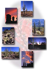
See more images from the -> American Southwest
11 January, 2011
Contact us ![]() Privacy policy
Privacy policy ![]() Terms of use
Terms of use
Copyright © Branimir Gjetvaj, all rights reserved
www.branimirphoto.ca